Highlights
- •
Whole-farm spatial appraisals are rare and often without yield data validation.
- •
We processed, validated and analysed a ten year whole-farm yield map data set.
- •
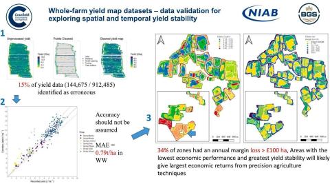
Wheat yield map data had a RMSE of 1.0 t/ha with a mean error of 8.1%.
- •
33% of the farm was losing >£100/ha compared to the best performing zone per field.
- •
Yield data validation is required when developing precision agriculture techniques.
Abstract
CONTEXT
Statistical methods used for delineation of field management zones and yield stability are frequently only applied to relatively small areas, with few studies performing rotational, whole-farm economic spatiotemporal appraisals. To enable accurate economic analysis, yield map datasets must contain minimal errors while cleaning procedures are often used to remove errors, it is rare that cleaned data is validated before its application.
OBJECTIVE
The objective of this study was to process, validate and combine spatial statistical approaches for a rotational yield map dataset from a whole-farm across 7 crops in a winter wheat based rotation. Developing a framework for using validated yield map datasets to support precision agriculture techniques that are applicable for farm-level decision making.
METHODS
The rotational completeness of a 10 year combine yield map dataset for a 435 ha farm in Eastern England was assessed. The dataset was cleaned statistically, and its accuracy assessed by comparison with recorded yields from trailer weigh cells. The cleaned, validated, and corrected yield map dataset was used to identify management zones across the whole farm using fuzzy clustering. The temporal stability of management zones and economic performance across the rotation was also assessed.
RESULTS AND DISSCUSION
Data cleaning methods removed 16% of data points, improving the degree of spatial correlation within the individual yield maps. Independent validation demonstrated varied accuracy of yield maps from combine harvester data and errors in wheat ranged from 0.53 to 1.53 t/ha RMSE. These errors have implications for researchers using combine yield data to develop and validate precision agriculture technologies. This data set required correction before yield data can be applied with confidence for on-farm decision making. Compared to the zones with the highest margin in each field, 34% of zones had an average annual margin loss of >£100 ha. The temporal stability of the resulting management zones also varied. Areas with the lowest economic performance and greatest yield stability across years will potentially see the greatest economic and environmental benefits from precision agriculture techniques.
SIGNIFICANCE
The accuracy of combine yield map data should not be assumed. The application of these datasets, including for the identification of management zones or in developing precision agriculture techniques should attempt to address this through data cleaning and validation procedures. Only then should it be used for on farm decision making, such as identifying areas with the most economic benefit by applying precision agriculture tools such as variable rate nutrient applications.
David E. Clarke, Elizabeth A. Stockdale, Jacqueline A. Hannam, Benjamin P. Marchant, Stephen H. Hallett,
Whole-farm yield map datasets – Data validation for exploring spatiotemporal yield and economic stability,
Agricultural Systems,
Volume 218,
2024,
103972,
ISSN 0308-521X,
https://doi.org/10.1016/j.agsy.2024.103972.
Download the full article below.